Android GPS Photo Camera for Field Teams

GPS timestamp photos
for work that needs
clear proof.

Capture high-resolution photos with live GPS coordinates, physical address, date, time, compass bearing, and verified watermark templates. Built for site inspections, civil engineering, construction, and property audits.

Sub-5m GPS Lock6+ Stamp StylesMulti-Page PDF Reports100% Offline Capable
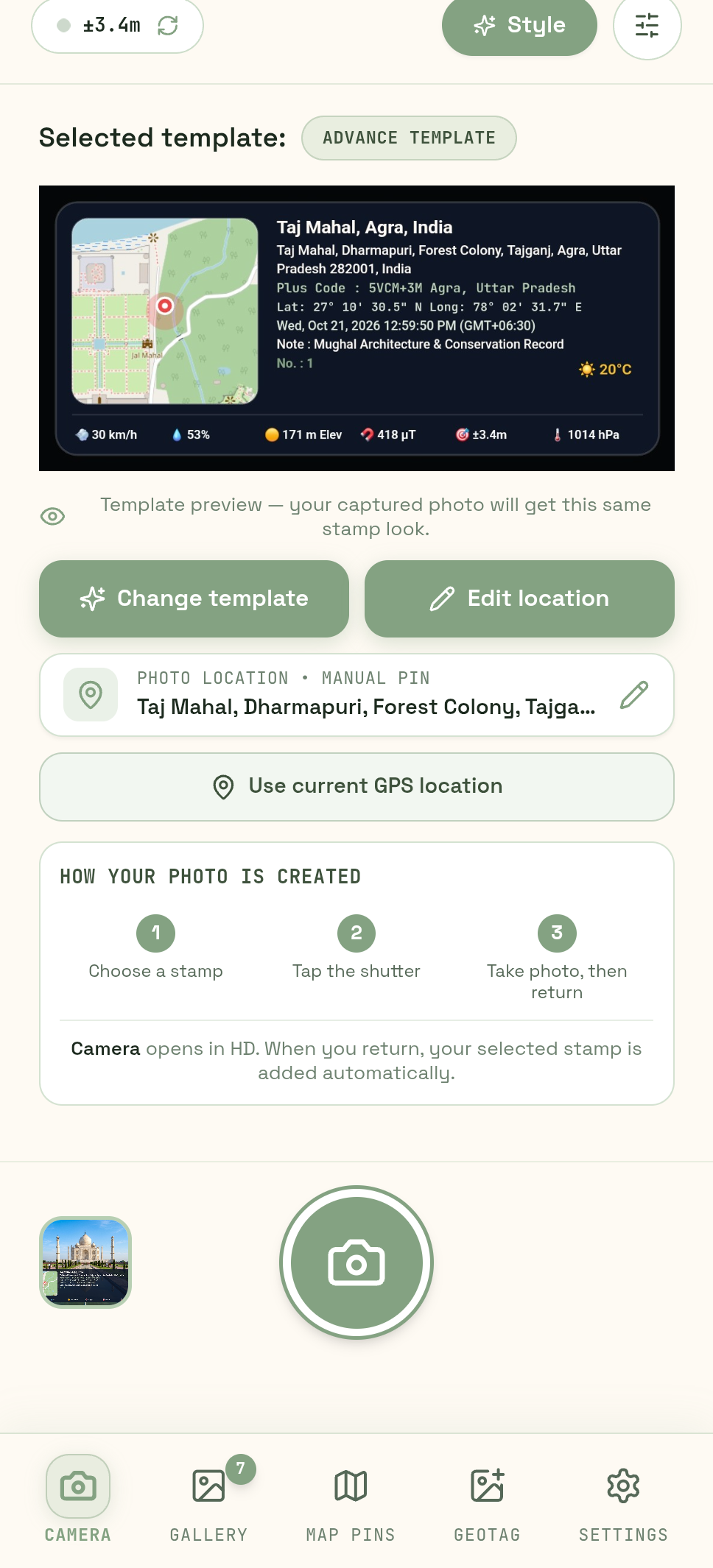
GPS - Geo Tagging Map Camera app showing live camera viewfinder with verified location stamp and telemetry
SELECTED STAMP
Advance GPS Template
±3.4m High Precision GPS
Real App Experience • 7 Showcase Screens

Make every field photo authoritative & clear.

GPS - Geo Tagging Map Camera combines satellite GPS telemetry, custom template controls, saved inspection logs, interactive map tracking, and client-ready PDF reporting into one high-performance tool.

GPS - Geo Tagging Map Camera preview showing live camera viewfinder, Taj Mahal location stamp and satellite telemetry
LIVE CAPTURE

Choose the stamp before you shoot

Select any of the 7 designer templates, inspect live GPS accuracy, azimuth, address, and elevation, then capture with zero guesswork.
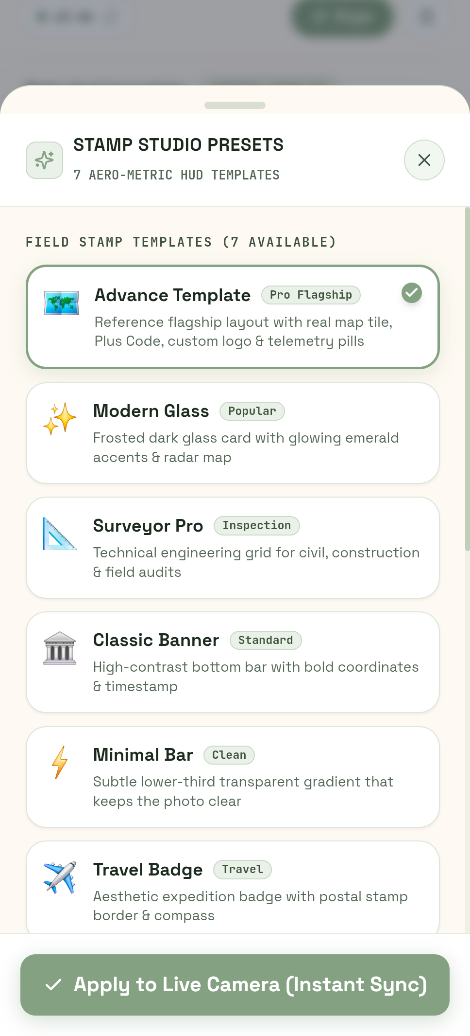
GPS - Geo Tagging Map Camera stamp studio presets showing 7 designer HUD templates
STAMP STUDIO PRESETS

7 Aero-Metric Designer Styles

Switch between Advance Template, Modern Glass, Surveyor Pro, Classic Banner, Minimal Bar, Travel Badge, and Compact Pill with one tap.
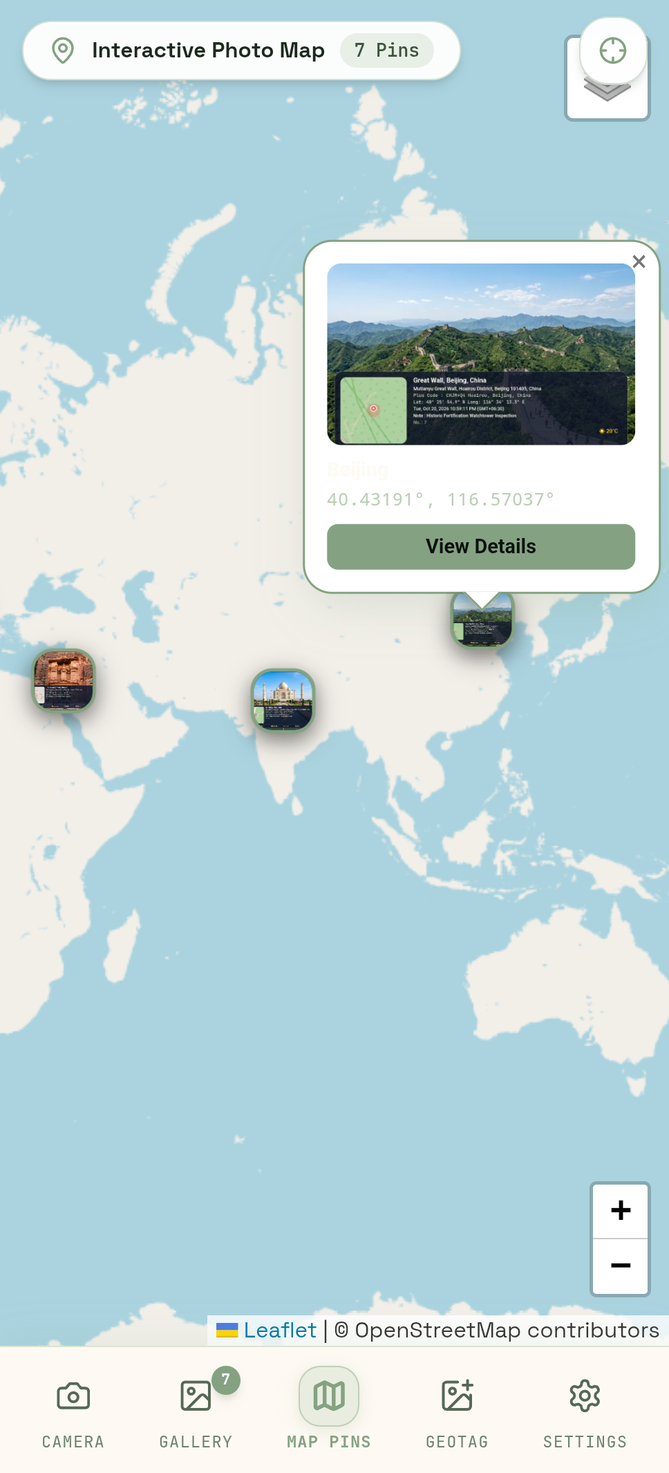
GPS - Geo Tagging Map Camera interactive photo map with worldwide GPS pins and photo cards
WORLDWIDE GPS MAP

Interactive Photo Map Tracking

Visualize all your tagged photos pinned on world maps. Toggle between street and satellite imagery, inspect clusters, and view popups.
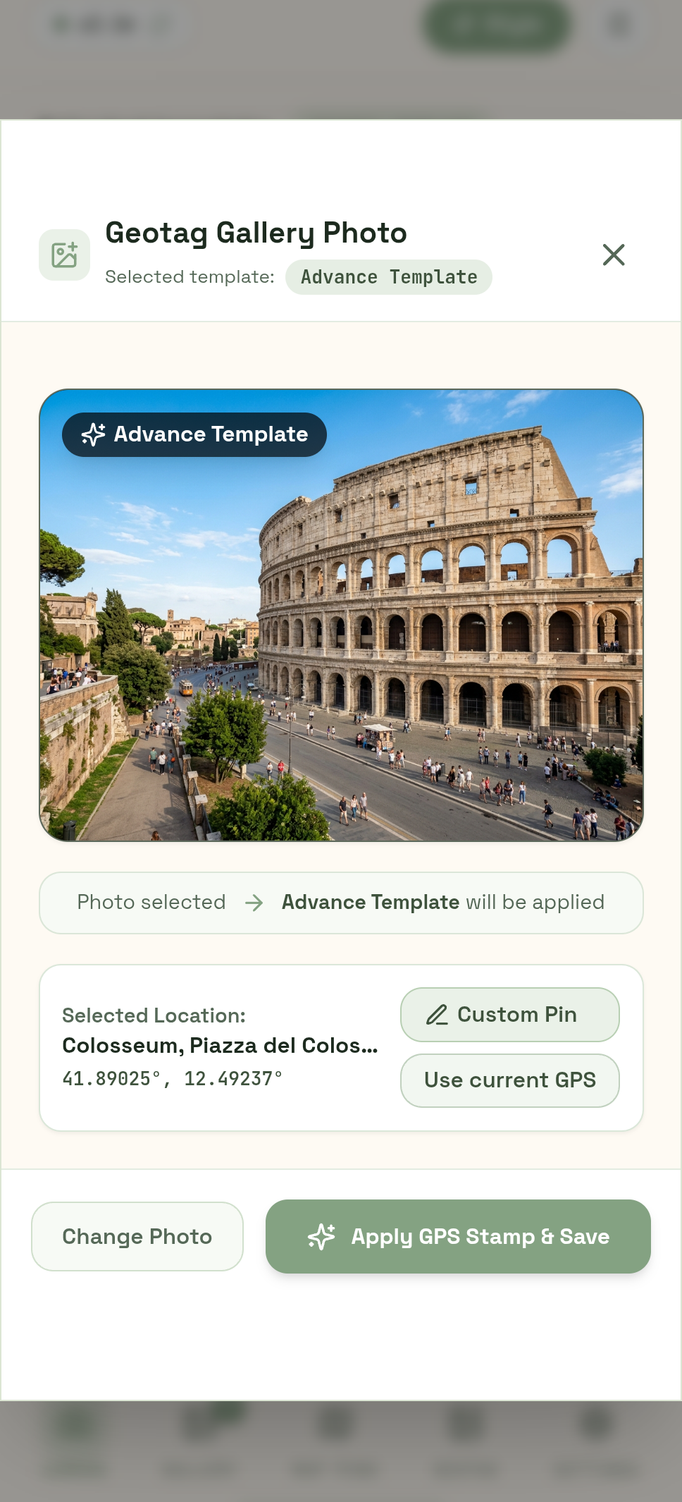
GPS - Geo Tagging Map Camera gallery photo geotagging screen with custom pin coordinates
GALLERY GEOTAGGING

Stamp an existing gallery photo

Import any prior photo from your device, apply custom location coordinates or search places, and burn verified stamps in seconds.
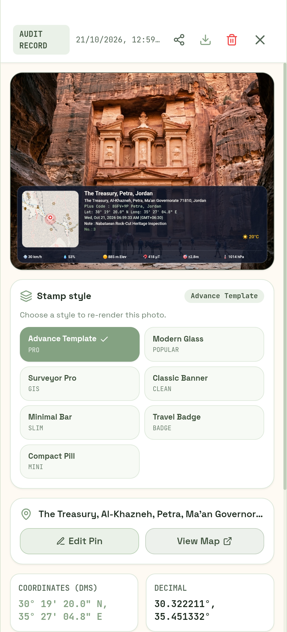
GPS - Geo Tagging Map Camera audit record with stamped photo, styles and coordinates
AUDIT & EXIF RECORD

Verified Audit-Ready Records

Review stamped photos with coordinates and notes, re-render templates, edit pins on Google Maps, or inspect full DMS telemetry.
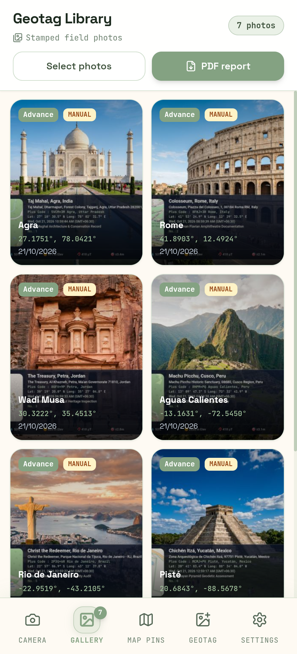
GPS - Geo Tagging Map Camera geotag library showing organized photo cards and PDF export options
GEOTAG LIBRARY

Organized Field Photo Catalog

Browse all tagged records with coordinates, timestamps, and template badges. Keep your entire site portfolio catalogued and organized.
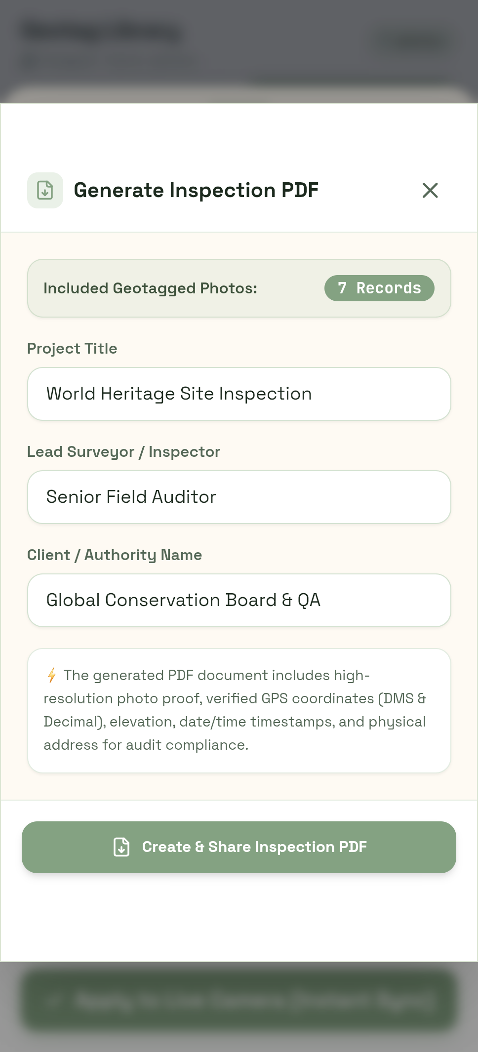
GPS - Geo Tagging Map Camera formal PDF site inspection report generator with project metadata
PDF INSPECTION REPORT

Client-Ready Inspection PDFs

Compile multiple field photos into a formal, structured PDF audit report complete with project name, surveyor credentials, and QA authority.

True EXIF Metadata Injected in Every Photo
Manual Place Search or Movable Map Pin
One-Click Formal PDF Inspection Reports
Photos Stay 100% Private on Your Device
Interactive Live Studio

Switch Templates in Real-Time

Test our designer geotagging templates directly in your browser. Every element is customizable, crystal-clear, and embedded permanently.

💡
Zero Blur Rendering: High-resolution canvas rendering ensures all coordinates, timestamps, and addresses stay razor-sharp at any zoom level.
GPS ±3.2mHD 4K
NNE
📍 PROJECT: SITE SURVEY 0410:45 AM
SG Highway, Bodakdev, Ahmedabad
23°1'21" N, 72°34'17" E • 53m Elev • 🧭 42° NE
☀️ 28°C • Clear Sky • Hum 45%
Built For Precision Documentation

Engineered For Field Professionals. Loved By Explorers.

Everything you need for verifiable photo documentation in construction, engineering, civil inspections, renewable energy, and field audits.

GPS - Geo Tagging Map Camera interactive world map showing geotagged photo pins
GLOBAL TRACKING

Interactive Photo Map & Global Pin Tracking

Browse your entire field survey catalogued on high-resolution world maps. Tap any pin to inspect the photo, coordinates, and exact address.

Automatic clustering of site photos across job locations
Toggle between OpenStreetMap and ESRI Satellite Imagery
Instant popup card preview with one-tap detail view
GPS - Geo Tagging Map Camera formal PDF site inspection report generator
OFFICIAL REPORTING

One-Click Site Inspection PDF Reports

Transform selected field photos into structured, multi-page PDF audit reports ready to deliver to clients, supervisors, or regulatory authorities.

Custom Project Title, Lead Surveyor, and Authority fields
Clean layout with photo proof, coordinates, elevation, and date/time
100% on-device generation with zero third-party cloud uploads
GPS - Geo Tagging Map Camera stamp studio presets showing 7 designer HUD templates
CUSTOM HUD STYLES

7 Aero-Metric Designer Stamp Templates

Choose the ideal overlay for your industry: from engineering grids for civil audits to high-contrast banners and modern glassmorphism.

Advance Flagship with live mini-map tile and plus codes
Surveyor Pro for civil engineering and infrastructure audits
Modern Glass, Classic Banner, Travel Badge, and Minimal Bar

Complete Toolkit for Ground Verification

Every tool is calibrated for high reliability under real field conditions.

High-Precision GPS Lock

Calculates latitude and longitude down to 6 decimal places (DMS & Decimal formats) with real-time accuracy indicators and elevation.

6+ Designer Stamp Styles

From ultra-clean Modern Glassmorphism to technical Surveyor Pro grids, travel badges, and minimal gradient bars.

True EXIF Metadata Injection

Unlike standard apps that merely paint pixels, we inject standard GPSLatitude, GPSLongitude, and Altitude tags directly into the JPEG headers.

Site Inspection PDF Generator

Export multiple field photos into a formal, structured Site Inspection Audit PDF report with project name, surveyor name, and coordinates.

Interactive Photo Map Gallery

Browse your entire photo roll on a full-screen interactive Leaflet map with custom camera pins and immediate detail previews.

Gallery Photo Geotagger

Select any older photo from your phone’s camera roll and apply high-precision location stamps and mini-maps in seconds.

Live Compass & Azimuth

Hardware magnetometer integration displays live orientation degrees and cardinal heading (N, NE, E, SE, S, SW, W, NW).

Offline Vector Radar Mode

When cell signal is unavailable on remote sites, the stamp seamlessly uses high-contrast vector radar maps so coordinates remain 100% readable.

Why Choose GPS - Geo Tagging Map Camera

How We Compare Against Other Apps

See why surveyors, field engineers, solar installers, and travelers choose us over basic camera stamps.

Features & Capabilities
GPS - Geo Tagging Map Camera (Our App)
Real-Time Satellite Precision HUD
Live GNSS lock, ±3m accuracy indicator, elevation & azimuth
No accuracy tolerance shown; frequent GPS drift
True Binary EXIF Header Injection
Writes native GPSLatitude/Longitude tags to JPEG headers for GIS
Pixel-only watermark; lost when cropped or edited
Designer Stamp Layouts
6+ styles: Modern Glass, Surveyor Pro, Classic Banner, Pills & Badges
1 rigid, low-contrast, non-customizable watermark
Site Inspection PDF Audit Reports
Built-in multi-page PDF generation with project details & signatures
Not available or locked behind monthly subscriptions
Offline Vector Radar Map Mode
Seamless vector radar fallback for remote zero-cell areas
Blank grey box or crashed map tile rendering
Gallery Photo Geotagging & Pin Drag
Stamp existing gallery photos + moveable pin & address search
Capture-only; cannot geotag existing camera roll photos
Got Questions?

Frequently Asked Questions

Everything you need to know about GPS geotagging, inspection reports, and EXIF tags.

The app accesses Android’s FusedLocationProvider and GNSS hardware directly, filtering for high-precision satellite locks. It also displays real-time accuracy tolerances (e.g., ±3.2m) right on the viewfinder so you know exactly when the signal is optimal.
Free Download on Android

Upgrade Your Field Photo Documentation Today

Add sub-meter GPS accuracy, professional stamps, and 1-click inspection PDF reports to every field capture.

Get it on Google Play
Android 9.0+• 100% Private Device Storage• No Forced Subscriptions